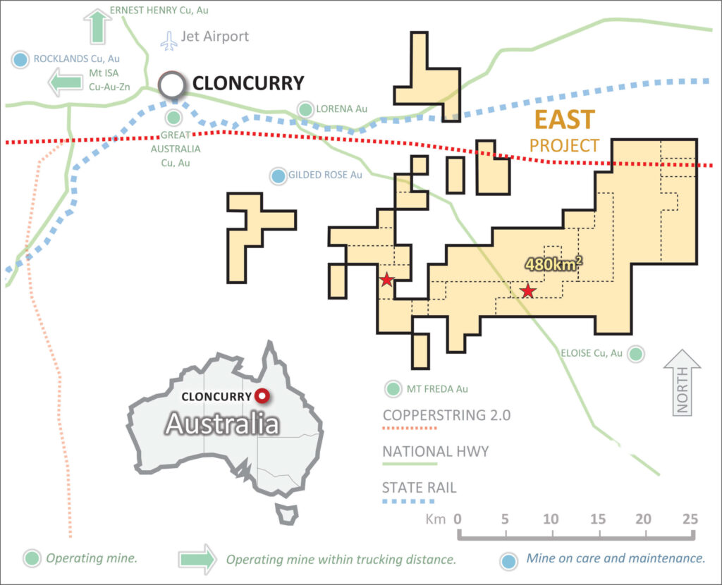
The Toole Creek tenements include Exploration Permits for Minerals (EPMs) with a combined total area of 480km2 centered approximately 32km south‐east of Cloncurry. The project area can be accessed from Cloncurry by sealed roads and the Townville‐Mt Isa railway line runs through the project area.

This highly prospective package of tenements is mainly located east of the Cloncurry Fault and north of the Selwyn‐Mount Dore corridor, which contains many IOCG deposits within a highly prospective belt that is bounded on the south by the Canteen “IOCG” Prospect, and on the east by the Eloise Deposit within the Soldiers Cap Group.
Mineralisation in the area is hosted by two major sequences of sedimentary and bimodal volcanic rocks viz., the Staveley Formation and Soldiers Cap Group.
These lithological packages were deposited during two periods of rifting. An earlier period between ~1770 and 1710 Ma, and a later period between ~1690 and 1650 Ma, (Page and Sun, 1998; Giles and Nutman, 2003). The earlier period of rifting (back‐arc extension?) overlaps the age of the intraplate “Argylla” volcanics that underlie Transitions tenements in the Mitakoodi domain. This indicates that back‐arc rifting and by association the effect of plume magmatism was regionally pervasive.
The Staveley Formation comprises intercalated calcareous metasiltstone and metasandstone and metabasalt (Beardsmore et al., 1988). As the Staveley Formation contains calcareous lithologies, these have been correlated with post‐rift carbonate‐bearing units (e.g., Overhang Jaspillite and Doherty and Corella formations) that crop out elsewhere in the Eastern Succession.
A number of IOCG deposits in the Eastern Fold Belt (e.g., Eloise and Osborne), are also hosted by the regionally extensive Soliders Cap Group. This sequence (Llewellyn Creek Volcanics and Mount Norna Quartzite) comprises a lower unit of rift‐related turbidite sequence comprising metapelites and quartzites as well as units of metabasalt that accumulated between 1693 ± 5 Ma and 1654 ± 4 Ma (Page, 1997; Page and Sun, 1998; Giles and Nutman, 2002).
The upper unit of the Soldiers Cap Group (Toole Creek Volcanics) has a maximum depositional age of 1657 ± 8 Ma; Page, 1997). Although dominated by meta‐basalt flows, it also contains a finingupward sequence siltstone, mudstone, and black shale that was deposited during late‐stage rifting.
The tenements are characterised by numerous small‐scale copper and gold mines that were predominately mined prior to 1960. At this time lack of infrastructure, and transport of ore by bullock or camel train, dictated that only high‐grade ore was mined and shipped.
Historical mines were generally identified by surface mineral exposures and only sporadic deep exploration activity was rarely undertaken in the area.
corp.admin@transitionresources.com.au
San Remo 3925, Victoria, Australia

Transition Resources Pty Ltd
(ABN 45 624 842 084)
corp.admin@transitionresources.com.au
San Remo 3925, Victoria, Australia

Transition Resources Pty Ltd
(ABN 45 624 842 084)
Copyright © 2023 Transition Resources Pty Ltd • transitionresources.com.au • all rights reserved
Coded by Dynamic Code